The ring and sector method is a relatively simple tool for spatial analysis on site level. It was designed especially for sites where the global spatial structure is characterized by the presence of a central hearth. In exceptional cases the method can also be applied at sites where there is no central hearth, but another suitable "centre". Around the centre of the hearth a system of rings and sectors is positioned, and the frequencies of artefacts in the rings and sectors are counted per class. The ring and sector approaches can be used independently, but many interesting insights may result from combining them. In principle, the ring and sector method is suitable for all kinds of material. The method was introduced and discussed by Stapert (1992). So far, the spatial patterns displayed by flint artefacts at some 30 Palaeolithic and Mesolithic sites in Europe have been analyzed by this method.
The idea behind the ring and sector method is that the hearth was a focal point in the daily life of a small group of people. The hearth attracted many activities, and also played an important role in social life. Therefore, using rings and sectors around the hearth centre seems to be a "natural" way of charting spatial patterns in such situations. An attractive aspect of the ring and sector method is the fact that it is closely related to Binford's "hearth model", based on ethno-archaeological research (Binford 1983). Binford described a characteristic pattern of "drop and toss zones" around outdoor hearths. The drop zone was located in the site-half where people sat and worked most of the time, to windward of the hearth, in order to avoid the smoke. It can be shown that the drop zone was contained in the tool-richest half.
The presence or absence of toss zones can be investigated relatively easily with the ring and sector method. For example, the "centrifugal effect" - the tendency of larger artefacts to end up farther from the hearth than small things - can be demonstrated by comparing the ring diagrams of small artefacts with those of large ones.
One of the most important applications of the ring and sector method relates to the question whether a hearth was located inside a dwelling or in the open. The ring distributions of the tools obtained for the analyzed sites are found to be of two different kinds: unimodal and multimodal (single-peak histograms or histograms with two or three peaks).
Bi- or trimodal diagrams are indicative of hearths inside dwellings; such diagrams were produced for Gönnersdorf, Etiolles (P15) and Verberie (2-D1). The first peak reflects the drop zone near the hearth. The second one is caused by the "barrier effect", and roughly coincides with the tent wall. At sites which were occupied for a longer time, a third peak, reflecting the door dump outside the entrance, may be present (see also Boekschoten & Stapert, 1993).
Unimodal distance distributions are associated with hearths in the open air. Pincevent, Niederbieber and Oldeholtwolde are among the sites which produced unimodal ring diagrams.
Trace lines (or ogives) constitute an alternative way of analyzing distance data. The artefacts are ranked according to their distance from the hearth centre; in the bottom left corner the artefact closest to the hearth is plotted, in the top right corner the farthest one. This results in characteristic S-shaped curves for artefact scatters around hearths in the open air. The steep part of the S-curve coincides with the only peak in the corresponding ring diagram: the drop zone. At dwelling sites, 2 or 3 S-shaped curve-parts will follow each other in the trace line. The first S reflects the drop zone. The second one is caused by the barrier effect of the wall which will have been located just after the end of the steep part. The third S-shaped curve-part, if present, may reflect the door dump outside the entrance. The advantage of trace lines over ring diagrams is that no class-division is needed. Therefore, they are more precise in establishing the position of the walls, especially when produced for 4 or 8 sectors separately.
Determining whether a hearth was inside a dwelling or in the open is a prerequisite for any meaningful intrasite spatial analysis. For example, the investigation of gender patterns in space can only be fruitful after the "tent problem" has been resolved, and the same goes for many other research goals.
Though the ring and sector method can help to solve the "tent problem", we must not expect miracles from it. Several types of complication may affect the analysis. For example, if a hearth was located a-centrally inside a tent, we would need ring diagrams per sector to demonstrate the presence of tent walls. Moreover, the smaller a tent the more difficult it will be to recognize it. In the case of tents with diameters of 5 m or more, rings of 50 cm will in general be adequate. However, in the case of tents with diameters below 5 m, we will mostly need rings of not more than 30 cm, in order to make the tent walls visible. Tents with diameters below ca. 3.5 m are difficult to recognize by the ring and sector method.
In a recent paper (Stapert & Johansen, 1995), several methodological improvements of the ring and sector method have been discussed. A procedure is described which makes it possible to use grid-cell data for ring and sector analysis. Up till now, ring and sector analysis could only be done for artefacts with individual co-ordinates. Using grid-cell data seems possible if the grid-cells are not larger than 50 cm. In the near future, we hope to incorporate these improvements into the ANALITHIC computer program.
Centroids are a means to display graphically the measure of dispersion of artefacts around a central point. This is simply done by drawing a circle at a map. The circle is at either the median distance from the central point or at the mean distance. The central point is calculated on basis of a sub-selection (plus area selection) in the current view. The method can be used for example to calculate a hearth centre on the basis of burnt artefacts, when no structure of a hearth was discovered during the excavation.
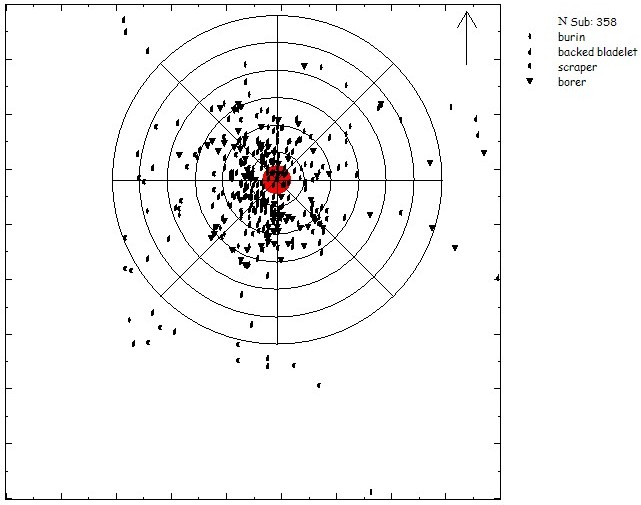
Pincevent unit T112: distribution map of tools with the ring & sector system.

Pincevent unit T112: sector graph of the tools. Sectors with more than the mean number of artefacts have a bar protruding outwards.
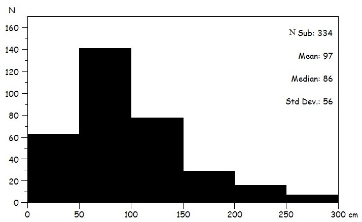
Pincevent unit T112: ring graph showing the number of tools at the distance from the hearth. The unimodality of the graph indicates that the hearth was probably in the open air and not inside a tent.